Both the Crow and Navajo Nations hold deep spiritual connections to specific mountains. The Crow consider the Crazy Mountains sacred, using them for vision quests and ceremony. The Navajo organize their entire cosmology around the Four Sacred Mountains, which define the boundaries of their world.
The Four Sacred Navajo Mountains
The Four Sacred Mountains mark the boundaries of the Navajo Nation and lie at the heart of Navajo spiritual life. In Navajo belief, each mountain is a living deity — assigned a color and a cardinal direction — and serves as a vital source of sustenance for the Navajo people. For decades, however, uranium mining and other extractive industries have degraded these sacred landscapes, causing lasting harm to Navajo communities.
Geographical Location
The Navajo hold mountains in especially high reverence, viewing prominent geographic features as bearers of supernatural power. The four sacred mountains define the corners of Navajo Country and are named in sunwise order, each paired with a directional color: Sisnaajiní (Blanca Peak) — white, east; Tsoodził (Mt. Taylor) — blue, south; Doko’oosłííd (San Francisco Peaks) — yellow, west; and Dibéntsaa (Hesperus Peak) — black, north. Within U.S. boundaries, these peaks fall across south-central Colorado, Grants, New Mexico, Flagstaff, Arizona, and the La Plata Mountains of Colorado.
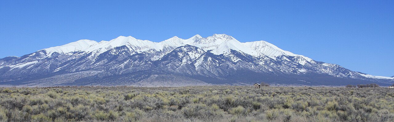
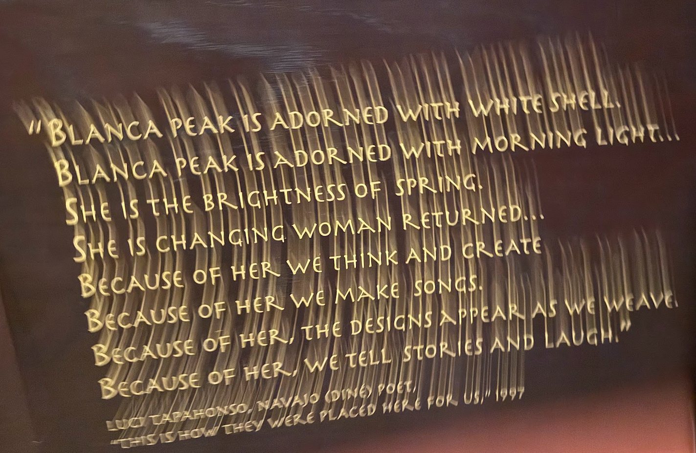
Blanca Peak
Sisnaajiní — known in English as Blanca Peak and called Pintsae’i’i by the Ute and Peeroradarath by the Tewa — stands as the eastern boundary of the Navajo world. Its Navajo name means “black belted mountain.” At 14,351 feet, it is the fourth highest summit in the Rocky Mountains and the tallest peak in both the Sangre de Cristo Range and the broader Sangre de Cristo Mountains. It sits roughly 9.6 miles north-northeast of the town of Blanca, Colorado, straddling the divide between Rio Grande National Forest and the Sangre de Cristo Land Grant — and it rises higher than any point in the United States east of its longitude. The peak once supported two small glaciers on its steep north face; both had vanished sometime after 1903.
The Crazy Mountains
The Crazy Mountains— often called simply “the Crazies” — are a rugged, isolated range in south-central Montana, rising between the Yellowstone and Musselshell rivers. Defined by jagged peaks topping 11,000 feet, more than 40 alpine lakes, and a dramatic 7,000-foot surge from the surrounding prairie, they are considered sacred ground by the Crow Nation.
Naming Legends
“Crazy Mountains” is a shortening of the original “Crazy Woman Mountains,” and two competing stories explain how that name came to be. The pioneer legend traces it to a woman who lost her mind and fled into the peaks after her family was massacred during westward expansion — a tale that overlaps with similar folklore surrounding Crazy Woman Canyon in Wyoming. The Native American explanation is more nuanced: the Crow originally called the range Awaxaawapìa, meaning “Ominous Mountains.” When early settlers asked what the mountains were called, the Crow responded with dramatic gestures meant to convey that this was a sacred, unpredictable place used for vision quests. The settlers misread those signals entirely, walking away with the impression that it was simply a place where people went crazy.
Geography & Features
The range stretches roughly 40 miles and includes 23 distinct peaks above 10,000 feet. Crazy Peak, at 11,214 feet, is the highest. The landscape is defined by steep rocky faces, dozens of jewel-like alpine lakes, and the rare Grasshopper Glacier.
Recreation & Access
The Crazies offer exceptional hiking, fishing, and mountaineering — but access is genuinely complicated. The range is an island of public land almost entirely hemmed in by private property, making it essential to stay on designated trails. Trailheads like the Half Moon Campground in Big Timber Canyon provide entry points on Forest Service land, but the checkerboard of public and private ownership demands careful navigation. For trip planning, the USDA Gallatin National Forest guidelines are the best starting point. Those interested in the area’s history and geology can also visit the Crazy Mountain Museum in Big Timber, Montana.
Monument Valley
Monument Valley is directly tied to the Navajo Nation. Monument Valley (Navajo: Tsé Biiʼ Ndzisgaii, meaning “valley of the rocks”) sits on the Arizona-Utah border within the Navajo Nation. Its iconic sandstone buttes — rising 400 to 1,000 feet from the desert floor — are among the most recognizable landscapes in the world, familiar from countless Western films, car commercials, and photographs.
Geography
The valley is part of the Colorado Plateau and is managed as Monument Valley Navajo Tribal Park, meaning it is owned and operated by the Navajo Nation rather than the federal government. The most famous formations are the three sandstone mittens — West Mitten Butte, East Mitten Butte, and Merrick Butte.
Cultural Significance
To the Navajo, Monument Valley is far more than a scenic backdrop. The land is considered sacred, woven into oral traditions and ceremonial life. It sits within the boundaries defined by the Four Sacred Mountains, placing it at the spiritual heart of the Navajo world.
Tourism
The park draws roughly 500,000 visitors a year. Access beyond the main valley drive requires a licensed Navajo guide, which keeps revenue within the community and ensures the land is treated with appropriate respect.